Squamish sits in the midst of some amazing places to hike. Garibaldi Provincial Park sprawls from Squamish up and beyond Whistler. Tantalus Provincial Park lays across the valley to the west and the beautiful and desolate, by comparison, Callaghan Valley to the north.
GaribaldiProvincialPark
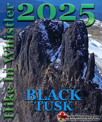
Garibaldi Provincial Park wraps around Squamish and is home to some amazing hiking trails. Garibaldi Lake, Panorama Ridge, Black Tusk and Elfin Lakes are all wonderful hiking destinations in this extraordinary Provincial Park so close to Squamish.
Skookumchuck Hot Springs (aka: T'sek Hot Springs and St Agnes Well Hot Springs) is located two hours north of Whistler along the edge of Lillooet River. The name Skookumchuck means "strong water" in the language of the Chinook people of the Pacific Northwest. The name is associated with the hot springs because of the nearby First Nation community of Skatin, which was once called Skookumchuck.
The Skookumchuck Hot Springs were also once known as St. Agnes Well during the days of the Fraser Canyon Gold Rush, but that name has fallen into disuse. They are also known locally by the Skatin name as the T'sek Hot Springs. Just 20 minutes north of Whistler you pass Nairn Falls Provincial Park. This is a great pit-stop on your way to Skookumchuck. Whether you hike the short, 1.2 kilometre trail to Nairn Falls or just check out the river viewpoint near the parking lot. Back on the highway, Pemberton is just 5 minutes north of Nairn Falls. This little town is your last chance for gas, food, alcohol, ect, as you will shortly be leaving civilization and entering the wilderness around Lillooet Lake. As you drive through Pemberton, just before Mount Currie you will see North Arm Farm on your right. Keep your eye out about 5 minutes past the McDonalds/Petrocan intersection and you will see it. This is a great place to see and wander around the beautiful farm grounds, visit the interesting farm animals and marvel at the amazing view of Mount Currie. The farm is free to visit and open weekends in the winter and everyday the rest of the year. They have a fantastic cafe with all sorts of baked goods and lunch items as well as various farm fresh produce for sale as well. Also, a great place for your last coffee before entering the wilderness.
Another 10 minutes on the highway further and you come to the turnoff to the In-Shuck-Ch Forest Service Road and begin the long and beautiful drive along Lillooet Lake. There are several excellent Lillooet Lake and Lillooet River viewpoints to stop and see along the way. From the obvious and frequent viewpoints along the road to the numerous and inviting campsites along the way. These campsites are great places to stop and see Lillooet Lake, have a beer, swim, or all three. Depending on the season, Lillooet Lake can be emerald, though cloudy green or muddy brown. This is all dependent on the spring runoff and especially the silty brown, Lillooet River that flows into Lillooet Lake from Pemberton. Lillooet Lake flows into the rushing and crashing Lillooet River and Skookumchuck sits at the edge of this beautiful river. Once you see the end of the lake and start driving along the river you are getting close to the hot springs.
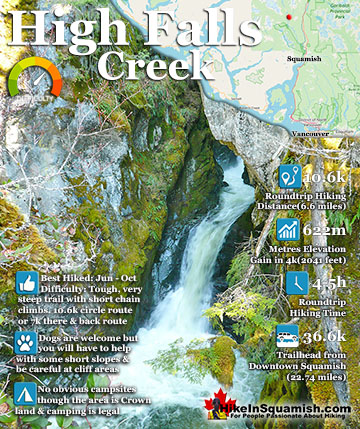
The High Falls Creek hike is a great hike not only for the beautiful scenery in and around the trail, but the drive to it as well. The often passed by Squamish Valley Road, opposite the Alice Lake Provincial ...
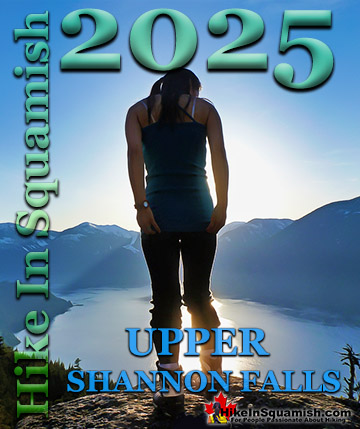
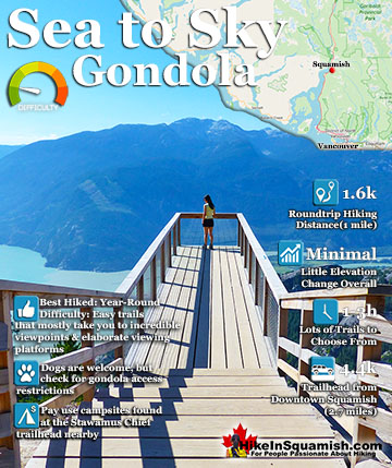
The Sea to Sky Gondola opened in the spring of 2014 and has rapidly expanded into a marvellous array of hiking trails and mountaintop attractions. Located between Stawamus Chief Provincial Park and Shannon Falls ...
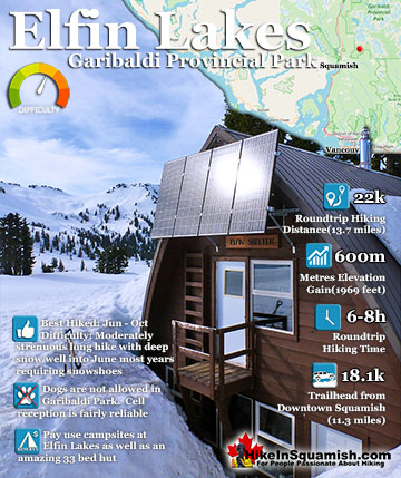
Elfin Lakes in Garibaldi Park is an absolutely phenomenal, though long, hiking, biking, snowshoeing and skiing trail that begins at the Diamond Head area in Squamish. From downtown Squamish, the trailhead is ...
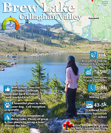
Brew Lake is beautiful mountain lake just a short drive south of Whistler and is relatively unknown and seldom hiked. Laying at the base of Mount Brew, Brew Lake lays in a massive alpine valley of enormous erratics. ...
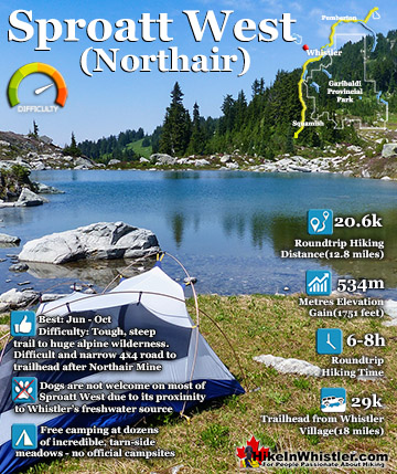
Mount Sproatt, or as it is known locally as just Sproatt, is one of the many towering mountains visible from Whistler Village. Above and beyond Alta Lake, directly across from Whistler Mountain and Blackcomb ...
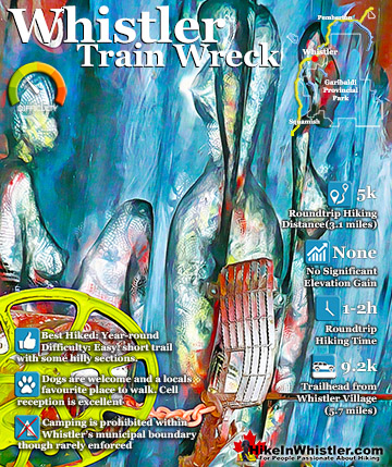
The trail to Whistler Train Wreck is an easy, yet varied route through deep forest, across a great suspension bridge over Cheakamus River, to a stunning array of wrecked train cars. The trail from your car ...
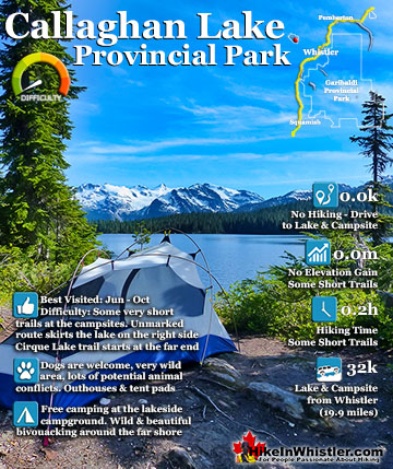
Callaghan Lake Provincial Park is a relatively untouched wilderness of rugged mountainous terrain. The valley walls were formed by relatively recent glaciation. Evidence of this can be seen in the ...
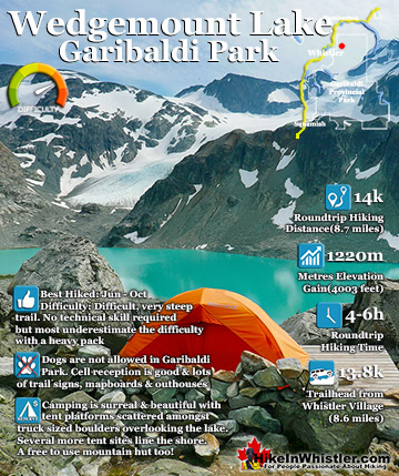
Wedgemount Lake itself is a magnificent destination for a day hike or spectacular overnight beneath the dazzling mountain peaks and stars. Many sleep under the stars on one of the many beautiful tent ...
Whistler is an amazing place to hike. Looking at a map of Whistler you see an extraordinary spider web of hiking trails. Easy trails, moderate trails and challenging hiking trails are all available. Another marvellous thing about Whistler is that Garibaldi Provincial ...
Squamish sits in the midst of some amazing places to hike. Garibaldi Park sprawls from Squamish up and beyond Whistler. Tantalus Provincial Park lays across the valley to the west and the beautiful and desolate, by comparison, Callaghan Valley to the north. Add to ...
Clayoquot Sound has a staggering array of hiking trails within it. Between Tofino and Ucluelet, Pacific Rim Park has several wilderness and beach trails, each one radically different from the last. The islands in the area are often Provincial parks on their own with ...
Victoria has a seemingly endless number of amazing hiking trails. Most take you to wild and beautiful Pacific Ocean views and others take you to tranquil lakes in beautiful BC Coastal Rainforest wilderness. Regional Parks and Provincial Parks are everywhere you turn ...
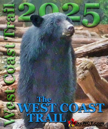
The West Coast Trail was created after decades of brutal and costly shipwrecks occurred along the West Coast of Vancouver Island. One shipwreck in particular was so horrific, tragic and unbelievable that it forced the creation of a trail along the coast, which ...


")