Squamish sits in the midst of some amazing places to hike. Garibaldi Provincial Park sprawls from Squamish up and beyond Whistler. Tantalus Provincial Park lays across the valley to the west and the beautiful and desolate, by comparison, Callaghan Valley to the north.
GaribaldiProvincialPark
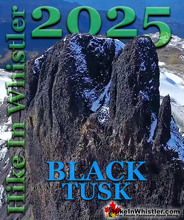
Garibaldi Provincial Park wraps around Squamish and is home to some amazing hiking trails. Garibaldi Lake, Panorama Ridge, Black Tusk and Elfin Lakes are all wonderful hiking destinations in this extraordinary Provincial Park so close to Squamish.
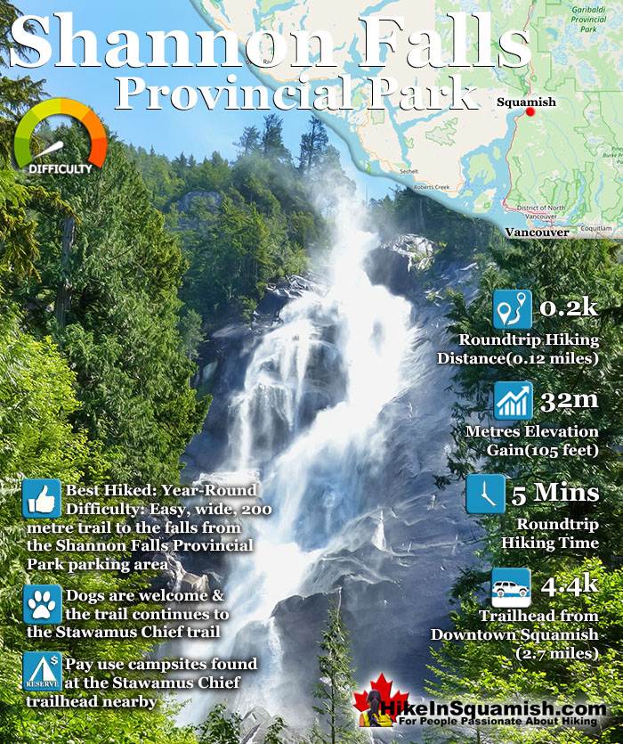
Shannon Falls towers above Howe Sound at 335 metres as the third tallest falls in BC. The wonderful, though very short trail winds through a beautiful old growth forest to get to the base of the falls. From your car to the viewpoint takes only about four minutes, however the trail continues a bit further to a higher viewpoint (five minutes higher).
You can even continue along the trail and join with the Stawamus Chief trail which goes to the three summits of The Chief. Shannon Falls Provincial Park has a concession stand as well as an information centre next to the parking area. This parking area is day use only, so if you are hoping to camp overnight in the area, you have to park at the Stawamus Chief parking lot, just a 1 minute drive north of the Shannon Falls lot. If you are planning to hike the Stawamus Chief, the Shannon Falls parking lot is arguably a better place to start from. You can take a look at Shannon Falls and then take the connecting trail to join onto the trail to The Chief. This route is only slightly longer, yet much more scenic. Once you connect to the Stawamus Chief trail, you will find almost constant stairs to be prepared for quite a workout comparable to the Grouse Grind in Vancouver.
The Chief is the mammoth rock face that towers over Squamish and has been iconic in this area for many centuries. Though hardly believable from looking at, the summit is only a one hour hike. In fact there are three peaks, South (First), Centre (Second), and North (Third). Each accessible from the single trailhead. The trailhead to The Chief is easy to find. From highway 99, in Squamish. Finding either Stawamus Chief Provincial Park or Shannon Falls Provincial Park are very easy. The Chief is visible for several kilometres and both The Chief and Shannon Falls are visible from the Sea to Sky Highway. From the highway watch for the provincial park signs for either park and. The large parking lots for Stawamus Chief Provincial Park are arranged next to the trailhead. There is a nice campground, with plenty of tent sites just up the trail. Shannon Falls is just 1 minute south of the entrance to The Chief on the Sea to Sky Highway and easily spotted.
Directions to Shannon Falls Provincial Park
From Cleveland Avenue and Highway 99 in Squamish (McDonalds is on this corner), drive south for about 2 minutes and watch for signs on your left. You can either park at the Stawamus Chief trailhead or the Shannon Falls trailhead. Both are close to each other but the Shannon Falls is much better for a day hike if you want to see both. Seeing both only takes a few minutes more than hiking just The Chief. If you are planning to camp overnight then The Chief trailhead is better to park as that is where the campsites are.
Explore Squamish Hiking Trails!
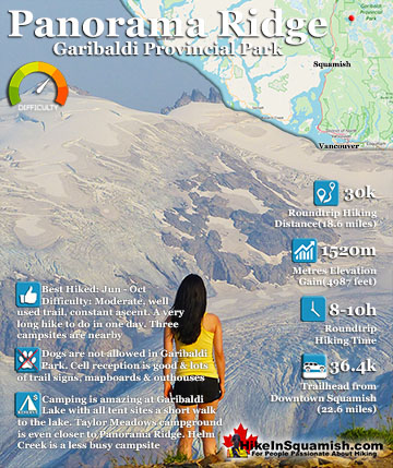
Panorama Ridge is easily one of the most amazing hikes in Garibaldi Provincial Park. The 15 kilometre(9.3 mile) hike from the trailhead at Rubble Creek to Panorama Ridge takes you through beautiful and deep ...
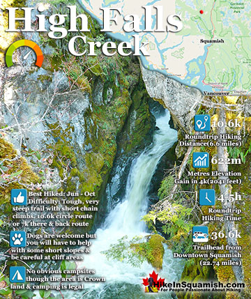
The High Falls Creek hike is a great hike not only for the beautiful scenery in and around the trail, but the drive to it as well. The often passed by Squamish Valley Road, opposite the Alice Lake Provincial ...
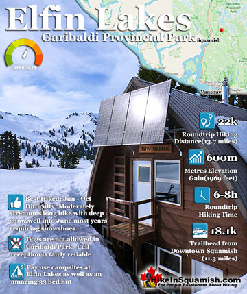
Elfin Lakes in Garibaldi Park is an absolutely phenomenal, though long, hiking, biking, snowshoeing and skiing trail that begins at the Diamond Head area in Squamish. From downtown Squamish, the trailhead is ...
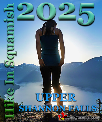
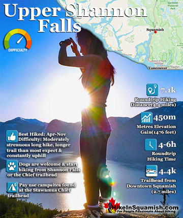
The wonderful Upper Shannon Falls trail, also called the Sea to Summit trail, branches off from the chaotically popular Stawamus Chief trail. About 15 minutes along the Stawamus Chief trail you will see a ...
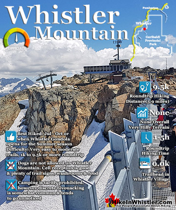
The alpine hiking trails on Whistler Mountain are the ultimate in luxurious hiking. Little hiking effort gets you amazing views of turquoise lakes, snowy mountain, valleys of flowers, waterfalls and ...
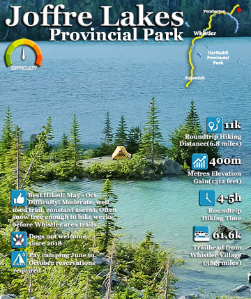
The three Joffre Lakes are some of the most stunning lakes you are likely to ever see. Each lake gets progressively more beautiful and impossibly turquoise from one to the next. By the third lake the intense ...
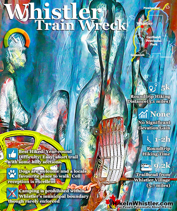
The trail to Whistler Train Wreck is an easy, yet varied route through deep forest, across a great suspension bridge over Cheakamus River, to a stunning array of wrecked train cars. The trail from your car ...
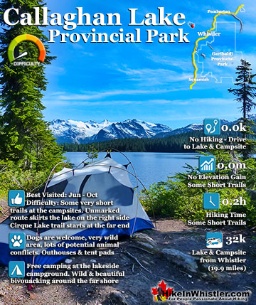
Callaghan Lake Provincial Park is a relatively untouched wilderness of rugged mountainous terrain. The valley walls were formed by relatively recent glaciation. Evidence of this can be seen in the ...
Whistler is an amazing place to hike. Looking at a map of Whistler you see an extraordinary spider web of hiking trails. Easy trails, moderate trails and challenging hiking trails are all available. Another marvellous thing about Whistler is that Garibaldi Provincial ...
Squamish sits in the midst of some amazing places to hike. Garibaldi Park sprawls from Squamish up and beyond Whistler. Tantalus Provincial Park lays across the valley to the west and the beautiful and desolate, by comparison, Callaghan Valley to the north. Add to ...
Clayoquot Sound has a staggering array of hiking trails within it. Between Tofino and Ucluelet, Pacific Rim Park has several wilderness and beach trails, each one radically different from the last. The islands in the area are often Provincial parks on their own with ...
Victoria has a seemingly endless number of amazing hiking trails. Most take you to wild and beautiful Pacific Ocean views and others take you to tranquil lakes in beautiful BC Coastal Rainforest wilderness. Regional Parks and Provincial Parks are everywhere you turn ...
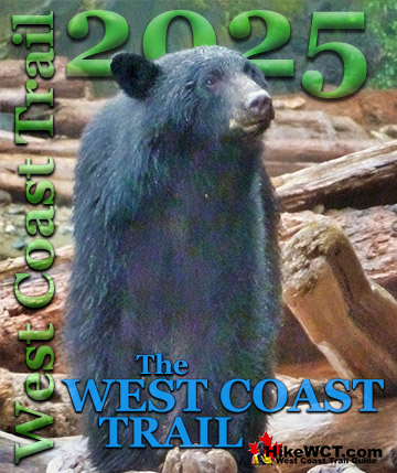
The West Coast Trail was created after decades of brutal and costly shipwrecks occurred along the West Coast of Vancouver Island. One shipwreck in particular was so horrific, tragic and unbelievable that it forced the creation of a trail along the coast, which ...


")