Squamish sits in the midst of some amazing places to hike. Garibaldi Provincial Park sprawls from Squamish up and beyond Whistler. Tantalus Provincial Park lays across the valley to the west and the beautiful and desolate, by comparison, Callaghan Valley to the north.
GaribaldiProvincialPark
Garibaldi Provincial Park wraps around Squamish and is home to some amazing hiking trails. Garibaldi Lake, Panorama Ridge, Black Tusk and Elfin Lakes are all wonderful hiking destinations in this extraordinary Provincial Park so close to Squamish.
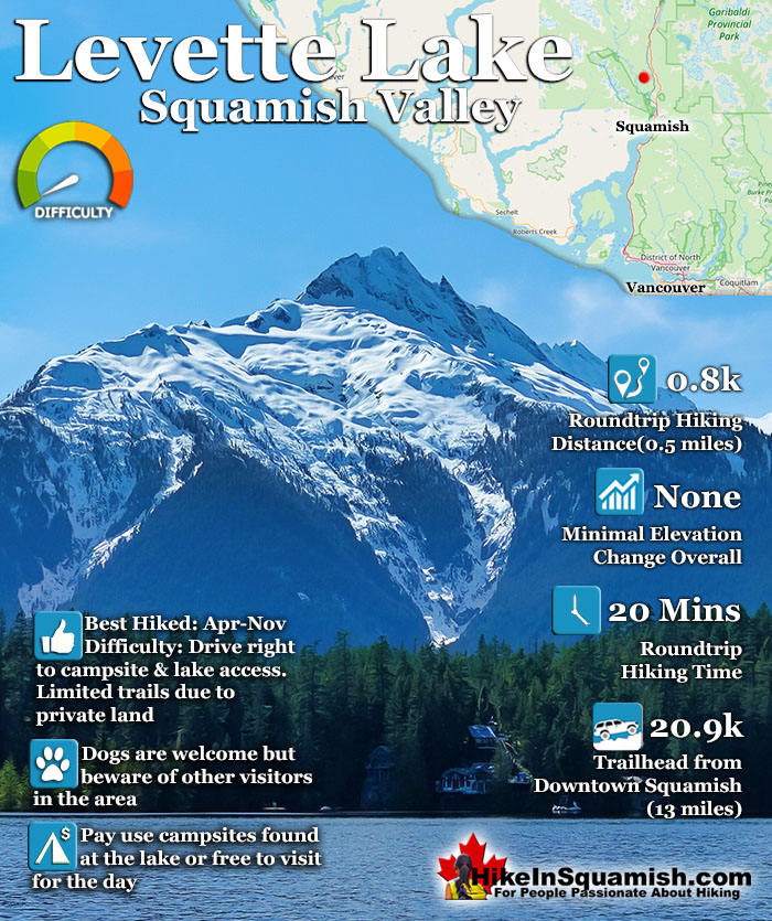
Levette Lake is a nice mountain lake located in the enormous Squamish Valley that drains the Squamish River into Howe Sound. There are some nice views and minimal elevation gain along the trail. The amazing Tantalus Range on a sunny day look fantastic from the shores of Levette Lake. There is a nice campground on the shore of the lake that is well laid out and very rustic.
It is located just a couple hundred metres from the parking area at the trailhead. The campground is very basic and quite nice. You won't find signs, garbage bins or any annoying signs of humanity to take away from the wonderful view of the lake and Tantalus Range across the lake. Camping is pay use at Levette Lake as it is a user maintained, pay use. Operated by Sites & Trails BC, fees are charged from June 1st to Oct 31. The overnight fee is $13 per night, per vehicle or group of 6 people, per site. Free to use outside this time, though snow will likely block access for most in the winter. The campground areas(there are several), consist of about a dozen dirt clearings in the forest. Some large, some small, separated by the natural features of the forest. There are plenty of seats made out of cut sections of logs and several fire rings left from previous campers. The campsite is surprisingly clean, though that largely depends on the previous group that used the area. There is an outhouse between the parking area and the campsites.
Driving Directions to Levette Lake
Just 9.8 kilometres north of Cleveland Avenue & Downtown Squamish, opposite the Alice Lake Provincial Park is the Squamish Valley Road (left if coming from Squamish/Vancouver or turn right if coming from Whistler). After the bridge, bear right onto Paradise Valley Road and after about 5-10 minutes watch for Levette Lake Forest Road on your left. Follow Levette Lake Forest Road as it ascends quickly on a part gravel and part paved road. After a couple minutes you will have to bear right at the Y junction. You will see a small sign indicating Levette Lake on the right and Evans Lake to the left. This is where the road gets quite bad with loose boulders and plenty of potholes. Cars can make it, however you have to go very slow to manage the loose boulders and deep potholes. The washouts(cross ditches) along this section are easily manageable in low clearance cars.
Explore Squamish Hiking Trails!
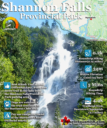
Shannon Falls towers above Howe Sound at 335 metres as the third tallest falls in BC. The wonderful, though very short trail winds through a beautiful old growth forest to get to the base of the falls. From ...
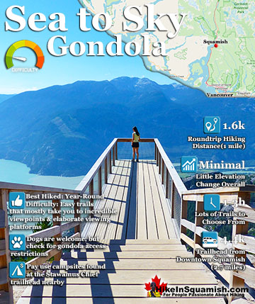
The Sea to Sky Gondola opened in the spring of 2014 and has rapidly expanded into a marvellous array of hiking trails and mountaintop attractions. Located between Stawamus Chief Provincial Park and Shannon Falls ...
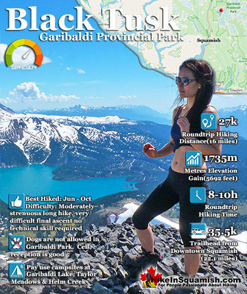
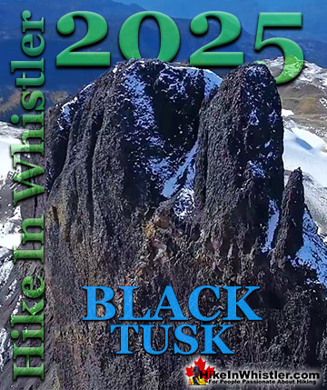
Black Tusk is the extraordinarily iconic and appropriately named mountain that can be seen from countless vantage points around Whistler. The massive black spire of crumbling rock juts out of the earth in an ...
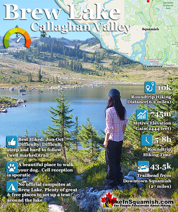
Brew Lake is beautiful mountain lake just a short drive south of Whistler and is relatively unknown and seldom hiked. Laying at the base of Mount Brew, Brew Lake lays in a massive alpine valley of enormous erratics. ...
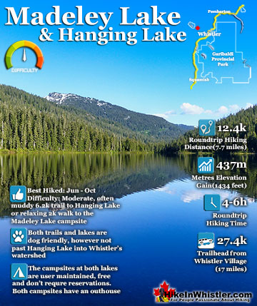
Madeley Lake is a gorgeous lake hidden high up in the wilderness of Callaghan Valley. The Callaghan Valley runs somewhat parallel to Whistler Valley, with the two valleys separated by Mount Sproatt. Sproatt is ...
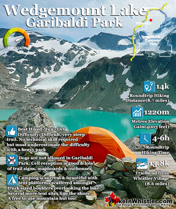
Wedgemount Lake itself is a magnificent destination for a day hike or spectacular overnight beneath the dazzling mountain peaks and stars. Many sleep under the stars on one of the many beautiful tent ...
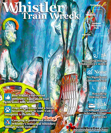
The trail to Whistler Train Wreck is an easy, yet varied route through deep forest, across a great suspension bridge over Cheakamus River, to a stunning array of wrecked train cars. The trail from your car ...
Whistler is an amazing place to hike. Looking at a map of Whistler you see an extraordinary spider web of hiking trails. Easy trails, moderate trails and challenging hiking trails are all available. Another marvellous thing about Whistler is that Garibaldi Provincial ...
Squamish sits in the midst of some amazing places to hike. Garibaldi Park sprawls from Squamish up and beyond Whistler. Tantalus Provincial Park lays across the valley to the west and the beautiful and desolate, by comparison, Callaghan Valley to the north. Add to ...
Clayoquot Sound has a staggering array of hiking trails within it. Between Tofino and Ucluelet, Pacific Rim Park has several wilderness and beach trails, each one radically different from the last. The islands in the area are often Provincial parks on their own with ...
Victoria has a seemingly endless number of amazing hiking trails. Most take you to wild and beautiful Pacific Ocean views and others take you to tranquil lakes in beautiful BC Coastal Rainforest wilderness. Regional Parks and Provincial Parks are everywhere you turn ...
The West Coast Trail was created after decades of brutal and costly shipwrecks occurred along the West Coast of Vancouver Island. One shipwreck in particular was so horrific, tragic and unbelievable that it forced the creation of a trail along the coast, which ...