Squamish sits in the midst of some amazing places to hike. Garibaldi Provincial Park sprawls from Squamish up and beyond Whistler. Tantalus Provincial Park lays across the valley to the west and the beautiful and desolate, by comparison, Callaghan Valley to the north.
GaribaldiProvincialPark
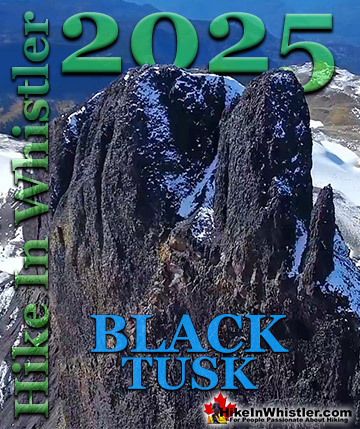
Garibaldi Provincial Park wraps around Squamish and is home to some amazing hiking trails. Garibaldi Lake, Panorama Ridge, Black Tusk and Elfin Lakes are all wonderful hiking destinations in this extraordinary Provincial Park so close to Squamish.
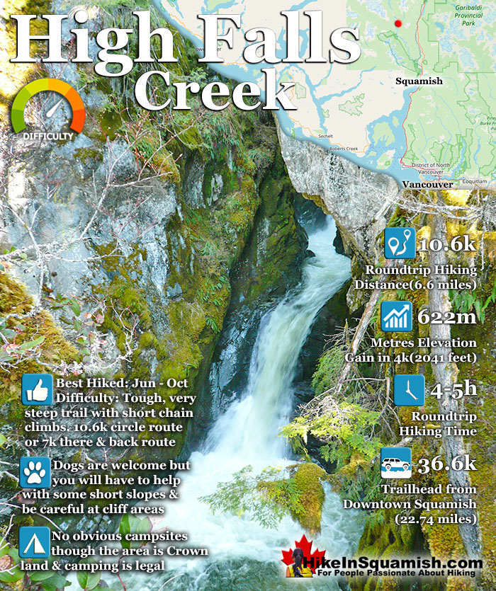
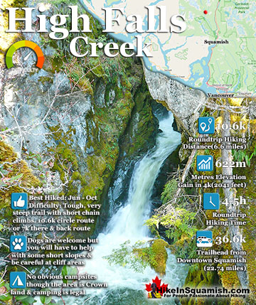
The High Falls Creek hike is a great hike not only for the beautiful scenery in and around the trail, but the drive to it as well. The often passed by Squamish Valley Road, opposite the Alice Lake Provincial Park access road, is wonderful. This glacier carved valley stretches on and on, along the majestic Squamish River. The trail is well marked and though steep at times is moderately challenging.
There are some short chain assisted areas to climb and overall the trail is fairly steep. You quickly gain 622 metres in about 4 kilometres. Past the beautiful falls viewpoints the trail leads to a few more viewpoints before ending at the Branch 200 FSR. You can either turn back and retrace your steps to the trailhead parking. Most prefer to walk the forest service road back to their car instead. It is much longer (almost 2 kilometres longer), but it is easy and relaxing and there are some stunning views of the river valley below. This road takes you back to the S Main FSR where you will turn left onto and walk about 1.4 kilometres to get back to your car. Tricouni Meadows and Peak are located near High Falls Creek and the Tricouni trail actually follows along High Falls Creek for some distance far above the High Falls Creek trail. To get to the Tricouni trailhead it is best to drive (instead of hiking from High Falls) as it is a few kilometres beyond the High Falls Creek trail.
Getting to High Falls Creek
Zero your odometer at Cleveland Avenue in Squamish and drive north on Highway 99. At 9.8 kilometres, opposite Alice Lake Provincial Park, turn left onto Squamish Valley Road. At 13.5 turn left to stay on Squamish Valley Road. Soon you will pass a hydroelectric power station on your right and cross a small bridge. Shortly after the power station, you will see another a small bridge at 36.6 kilometres, this is the bridge over High Falls Creek. Park just before the bridge and walk across the bridge to see the trailhead sign to High Falls Creek immediately past it on the right.
Explore Squamish Hiking Trails!
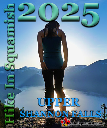
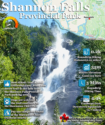
Shannon Falls towers above Howe Sound at 335 metres as the third tallest falls in BC. The wonderful, though very short trail winds through a beautiful old growth forest to get to the base of the falls. From ...
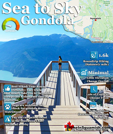
The Sea to Sky Gondola opened in the spring of 2014 and has rapidly expanded into a marvellous array of hiking trails and mountaintop attractions. Located between Stawamus Chief Provincial Park and Shannon Falls ...
The High Falls Creek hike is a great hike not only for the beautiful scenery in and around the trail, but the drive to it as well. The often passed by Squamish Valley Road, opposite the Alice Lake Provincial ...
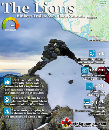
The Lions or Twin Sisters lie in North Vancouver, south of Squamish. The two distinct, rocky peaks are visible from downtown Vancouver. The one on the left, the one pictured above, can be climbed. You don't ...
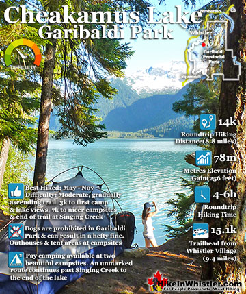
Cheakamus Lake is a wonderfully relaxing way to get in the wilderness easily and quickly from Whistler Village. The trail begins on the far side of Whistler Mountain, 8 kilometres from the Sea to Sky ...
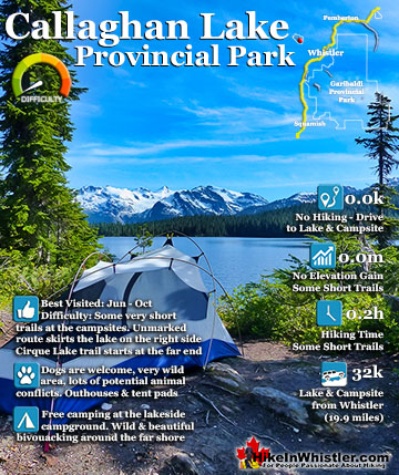
Callaghan Lake Provincial Park is a relatively untouched wilderness of rugged mountainous terrain. The valley walls were formed by relatively recent glaciation. Evidence of this can be seen in the ...
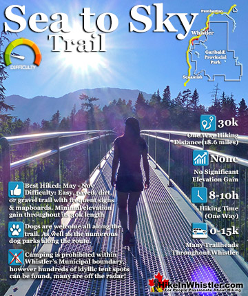
The Sea to Sky Trail is a 180 kilometre multi-use trail that runs from Squamish to D'Arcy. The trail is still under construction in many parts, however, the amazing route through Whistler is finally in ...
Whistler is an amazing place to hike. Looking at a map of Whistler you see an extraordinary spider web of hiking trails. Easy trails, moderate trails and challenging hiking trails are all available. Another marvellous thing about Whistler is that Garibaldi Provincial ...
Squamish sits in the midst of some amazing places to hike. Garibaldi Park sprawls from Squamish up and beyond Whistler. Tantalus Provincial Park lays across the valley to the west and the beautiful and desolate, by comparison, Callaghan Valley to the north. Add to ...
Clayoquot Sound has a staggering array of hiking trails within it. Between Tofino and Ucluelet, Pacific Rim Park has several wilderness and beach trails, each one radically different from the last. The islands in the area are often Provincial parks on their own with ...
Victoria has a seemingly endless number of amazing hiking trails. Most take you to wild and beautiful Pacific Ocean views and others take you to tranquil lakes in beautiful BC Coastal Rainforest wilderness. Regional Parks and Provincial Parks are everywhere you turn ...
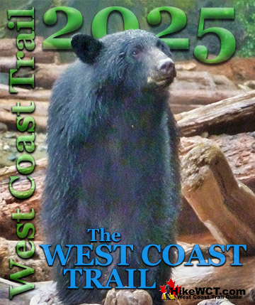
The West Coast Trail was created after decades of brutal and costly shipwrecks occurred along the West Coast of Vancouver Island. One shipwreck in particular was so horrific, tragic and unbelievable that it forced the creation of a trail along the coast, which ...


")