Squamish sits in the midst of some amazing places to hike. Garibaldi Provincial Park sprawls from Squamish up and beyond Whistler. Tantalus Provincial Park lays across the valley to the west and the beautiful and desolate, by comparison, Callaghan Valley to the north.
GaribaldiProvincialPark
Garibaldi Provincial Park wraps around Squamish and is home to some amazing hiking trails. Garibaldi Lake, Panorama Ridge, Black Tusk and Elfin Lakes are all wonderful hiking destinations in this extraordinary Provincial Park so close to Squamish.
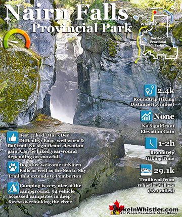
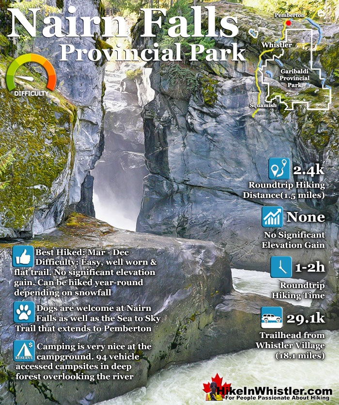
Nairn Falls is a swirling, crashing and chaotic waterfall that surrounds you from the deluxe viewing platform that allows you to safely watch it from above. The beautiful, green water rushes through the deep and angular channels of rock. Nairn Falls Provincial Park is centered around a very large campground and the short, 1.2 kilometre trail to the falls.
Very nice trail along the river to the falls
Informative signs at the falls explaining how it formed
Though the BC Parks website describes Nairn Falls as 60 metres high, the description is a bit misleading. You won't find a marvellously abrupt drop into a deep chasm like to see with Brandywine Falls. Nairn Falls has a very different shape to it, but is every bit as interesting and scenic. More so, in fact, due to the interesting geological information you find at the main viewpoint over the falls. Nairn Falls crash through various narrow and wide areas, and though the cumulative drop is 60 metres, what you see is a series of 10 to 20 metre falls through a deep, zig-zagging canyon. There are very nicely constructed railings, fences and viewing areas as well as a walkway that guides you to the best views. With such abruptly steep rock all around, the area would be potentially dangerous. Evidently there have been deaths here before. A cross, reverently placed across the chasm from the viewing platform, indicates of some tragic event. Nairn Falls Provincial Park is located just a short 20 to 30 minute drive north of Whistler. From the large parking lot the well marked trail runs along the Green River for 1.2k to Nairn Falls. The trail is very easy and is hike-able year-round. Though considerable snow falls in the winter months here, the popular trail remains easy to follow, and snowshoes are usually not needed.
Nairn Falls Hiking Trail Map
Most visitors to Nairn Falls Provincial Park just see Nairn Falls, however, to the left, beyond the campsites the Green River is beautiful. A short trail takes you down to a wide bend in the river and you find yourself in what looks like a large beach. It is a hidden bit of paradise with the crystal clear, green water flowing over polished rocks. The whole are is in almost constant sunlight despite being in the middle of the forest. On warm, summer days you will find people swimming, sipping beers on the rock cliffs across the river and generally having an amazing time in this usually forgotten corner of the park.
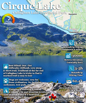
Cirque Lake is a wild and beautiful lake that hides high above and beyond Callaghan Lake in Callaghan Lake Provincial Park. What makes Cirque Lake special among the other sensationally beautiful lakes in the ...
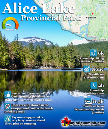
Alice Lake is a great place for camping swimming, fishing and hiking. Alice Lake Provincial Park is comprised of four lakes, Stump, Fawn and Edith Lake as well as the much larger Alice Lake. There is a nice trail, ...
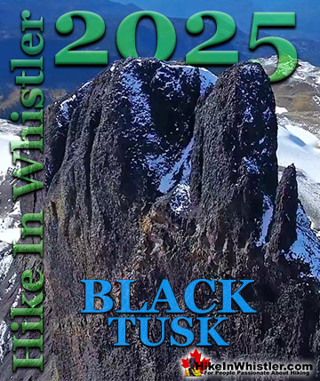
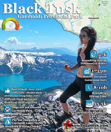
Black Tusk is the extraordinarily iconic and appropriately named mountain that can be seen from countless vantage points around Whistler. The massive black spire of crumbling rock juts out of the earth in an ...
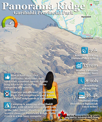
Panorama Ridge is easily one of the most amazing hikes in Garibaldi Provincial Park. The 15 kilometre(9.3 mile) hike from the trailhead at Rubble Creek to Panorama Ridge takes you through beautiful and deep ...
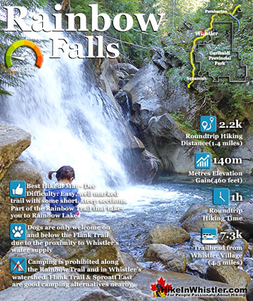
The short, scenic and easy hiking trail to Rainbow Falls is found at the same, much more well known trailhead for Rainbow Lake. The trailhead is marked as the Rainbow Trail and the trail quickly ascends ...
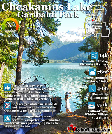
Cheakamus Lake is a wonderfully relaxing way to get in the wilderness easily and quickly from Whistler Village. The trail begins on the far side of Whistler Mountain, 8 kilometres from the Sea to Sky ...
Nairn Falls is a swirling, crashing and chaotic waterfall that surrounds you from the deluxe viewing platform that allows you to safely watch it from above. The beautiful, green water rushes through the deep and ...
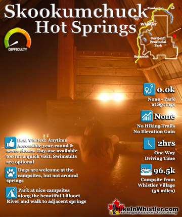
Skookumchuck Hot Springs (aka: T'sek Hot Springs and St Agnes Well Hot Springs) is located two hours north of Whistler along the edge of Lillooet River. The name Skookumchuck means "strong water" in the ...
Whistler is an amazing place to hike. Looking at a map of Whistler you see an extraordinary spider web of hiking trails. Easy trails, moderate trails and challenging hiking trails are all available. Another marvellous thing about Whistler is that Garibaldi Provincial ...
Squamish sits in the midst of some amazing places to hike. Garibaldi Park sprawls from Squamish up and beyond Whistler. Tantalus Provincial Park lays across the valley to the west and the beautiful and desolate, by comparison, Callaghan Valley to the north. Add to ...
Clayoquot Sound has a staggering array of hiking trails within it. Between Tofino and Ucluelet, Pacific Rim Park has several wilderness and beach trails, each one radically different from the last. The islands in the area are often Provincial parks on their own with ...
Victoria has a seemingly endless number of amazing hiking trails. Most take you to wild and beautiful Pacific Ocean views and others take you to tranquil lakes in beautiful BC Coastal Rainforest wilderness. Regional Parks and Provincial Parks are everywhere you turn ...
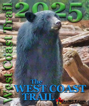
The West Coast Trail was created after decades of brutal and costly shipwrecks occurred along the West Coast of Vancouver Island. One shipwreck in particular was so horrific, tragic and unbelievable that it forced the creation of a trail along the coast, which ...


")