Squamish sits in the midst of some amazing places to hike. Garibaldi Provincial Park sprawls from Squamish up and beyond Whistler. Tantalus Provincial Park lays across the valley to the west and the beautiful and desolate, by comparison, Callaghan Valley to the north.
GaribaldiProvincialPark
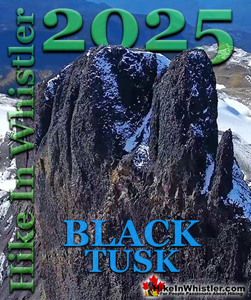
Garibaldi Provincial Park wraps around Squamish and is home to some amazing hiking trails. Garibaldi Lake, Panorama Ridge, Black Tusk and Elfin Lakes are all wonderful hiking destinations in this extraordinary Provincial Park so close to Squamish.
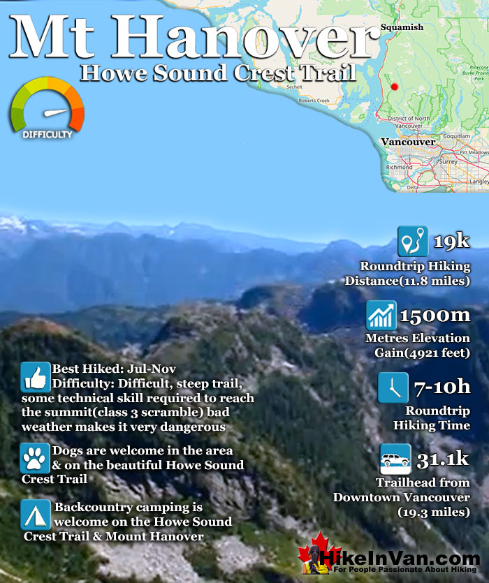
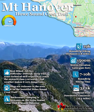
Mount Hanover is another amazing and accessible peak in the North Shore mountains. Located in the beautiful Cypress Provincial Park, Mount Hanover is among several other prominent summits on the amazing Howe Sound Crest Trail. You can reach Mount Hanover from the Howe Sound Crest Trail if you begin your hike from the Cypress Mountain Resort, however reaching it from the trailhead in Lions Bay is much shorter.
This trailhead is also used to reach The Lions, Mount Harvey and Brunswick Mountain. There is no established route to Hanover after you leave the Howe Sound Crest Trail. Fortunately Hanover towers visibly in the distance at all times, so the best method to reach the summit is to route find your way as you go. This of course makes Mount Hanover a potentially dangerous hike if you are unprepared or unlucky with the weather. Be sure to have a GPS and topo map with you and know what you are doing. The route to the Howe Sound Crest Trail from the Lions Bay trailhead(Lions Binkert trailhead) is the same as the route you would take to Brunswick Mountain so it is well marked with flagging tape though there are few written signs. The trail is challenging as you gain considerable elevation in a short distance, 1550 metres in just 7.3 kilometres. The first half of the trail is fairly easy as you follow first a disused logging road for about 15 minutes (bear right at a fork), then a wide and fairly straight trail for another 20 minutes until you reach another junction. Take the trail (overgrown logging road) to the left which is well marked with flagging tape. You will shortly cross Magnesia Creek and the trail steepens as the logging road/trail becomes a trail and soon you will see a fork.
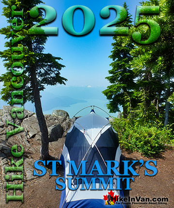
Take the fork to the right and soon you will come to the Howe Sound Crest Trail. From here you must route find your way to the very visible Mount Hanover. Mount Hanover is part of the amazing Howe Sound Crest Trail in Cypress Provincial Park and is one of the many beautiful peaks to be climbed if desired on the 29 kilometre trail. Among the hiker friendly mountains (in order from Cypress north) on the Howe Sound Crest Trail are: Mount Strachan, St Mark's Summit, Unnecessary Mountain, The Lions, Mount Harvey, Mount Hanover, Brunswick Mountain and finally Deeks Peak.
Explore Vancouver Hiking Trails!
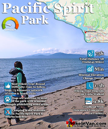
Pacific Spirit Park surrounds the University of British Columbia on the shores of Georgia Straight. The park has a beautiful array of trails, 73 kilometres in total, that run along beaches, some old growth ...
Mount Hanover is another amazing and accessible peak in the North Shore mountains. Located in the beautiful Cypress Provincial Park, Mount Hanover is among several other prominent summits on the amazing Howe ...
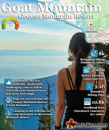
Goat Mountain is a beautiful mountain to hike from Grouse Mountain. It is challenging at times but fairly relaxing overall. It is just 4k from the Grouse Mountain Chalet and should only take 3-4 hours ...
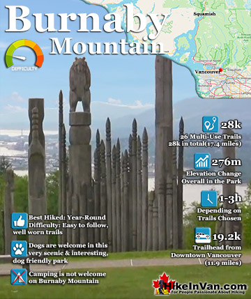
Burnaby Mountain, just 30 minutes east of downtown Vancouver has a nice network of popular trails with fantastic views of Vancouver, Burrard Inlet and beyond. The trails link to the wonderful Trans Canada ...
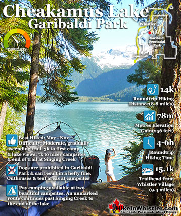
Cheakamus Lake is a wonderfully relaxing way to get in the wilderness easily and quickly from Whistler Village. The trail begins on the far side of Whistler Mountain, 8 kilometres from the Sea to Sky ...
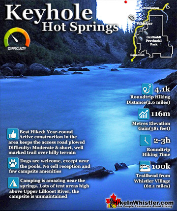
Keyhole Hot Springs(sometimes called Pebble Creek Hot Springs) is located 100 kilometres from Whistler(Village Gate Blvd). Though most of the 100 kilometres is on logging roads, it is driveable by most cars ...
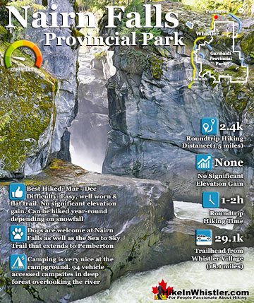
Nairn Falls is a swirling, crashing and chaotic waterfall that surrounds you from the deluxe viewing platform that allows you to safely watch it from above. The beautiful, green water rushes through the deep and ...
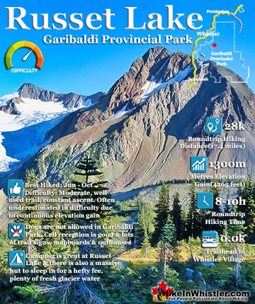
Russet Lake is a surreal little paradise that lays at the base of The Fissile. The Fissile is the strikingly bronze mountain visible from Whistler Village. From the Village look into the distance at the Peak2Peak ...
Whistler is an amazing place to hike. Looking at a map of Whistler you see an extraordinary spider web of hiking trails. Easy trails, moderate trails and challenging hiking trails are all available. Another marvellous thing about Whistler is that Garibaldi Provincial ...
Squamish sits in the midst of some amazing places to hike. Garibaldi Park sprawls from Squamish up and beyond Whistler. Tantalus Provincial Park lays across the valley to the west and the beautiful and desolate, by comparison, Callaghan Valley to the north. Add to ...
Clayoquot Sound has a staggering array of hiking trails within it. Between Tofino and Ucluelet, Pacific Rim Park has several wilderness and beach trails, each one radically different from the last. The islands in the area are often Provincial parks on their own with ...
Victoria has a seemingly endless number of amazing hiking trails. Most take you to wild and beautiful Pacific Ocean views and others take you to tranquil lakes in beautiful BC Coastal Rainforest wilderness. Regional Parks and Provincial Parks are everywhere you turn ...
The West Coast Trail was created after decades of brutal and costly shipwrecks occurred along the West Coast of Vancouver Island. One shipwreck in particular was so horrific, tragic and unbelievable that it forced the creation of a trail along the coast, which ...


")