Squamish sits in the midst of some amazing places to hike. Garibaldi Provincial Park sprawls from Squamish up and beyond Whistler. Tantalus Provincial Park lays across the valley to the west and the beautiful and desolate, by comparison, Callaghan Valley to the north.
GaribaldiProvincialPark
Garibaldi Provincial Park wraps around Squamish and is home to some amazing hiking trails. Garibaldi Lake, Panorama Ridge, Black Tusk and Elfin Lakes are all wonderful hiking destinations in this extraordinary Provincial Park so close to Squamish.
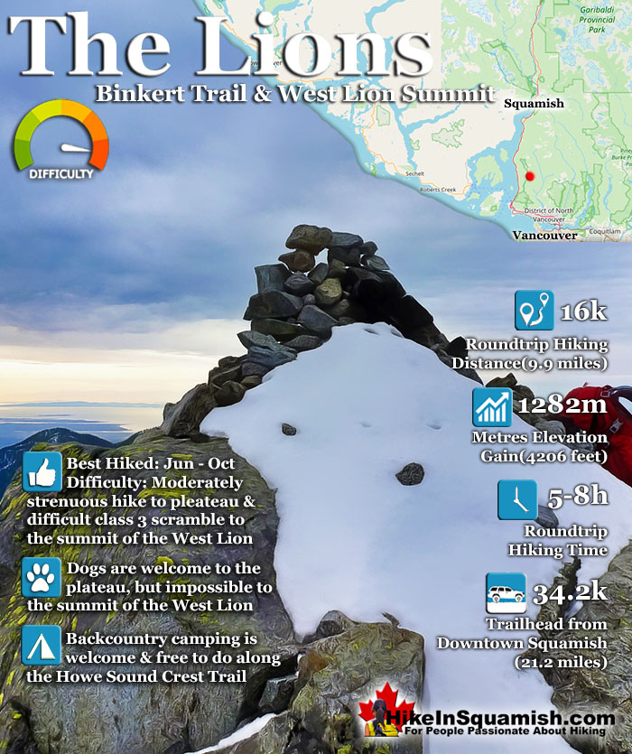
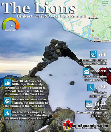
The Lions or Twin Sisters lie in North Vancouver, south of Squamish. The two distinct, rocky peaks are visible from downtown Vancouver. The one on the left, the one pictured above, can be climbed. You don't have to, however, as the plateau before this difficult summit has amazing views. In fact, most finish their hike to The Lions here at this wonderful plateau, with the towering West Lion so close.
It is beautiful enough, tough, and very rewarding to get to this plateau. To get to the West Lion summit is considerably more challenging and comparatively more rewarding. The view from the top of the West Lion is spectacular. Howe Sound stretches out into the blue distance. A tough but wonderful hike in easy conditions. In wet, cold, or snowy weather, a summit attempt is very treacherous. Not only is cold, snowy, icy or wet weather a consideration due to the slippery footing and hand holds, but also cloudy and foggy weather. Fog can reduce visibility enough to make finding your way, and more importantly, finding your return route, difficult to find. Losing your way from the top of the West Lion has proven fatal in the past. The first half of the Lions Binkert Trail is very easy as you follow a disused, though beautifully overgrown logging road gently uphill. After the first 30 minutes of hiking you come to a Y junction, take the path on the right and continue as the path eventually narrows and beautiful views of Howe Sound become visible. You will pass two waterfalls, then come to a sign (The Lions>>) that blocks the old, very overgrown logging road and points to a narrow path to the right. You will cross Harvey Creek over a beautiful little bridge with wonderful views, then the first significant uphill hiking starts. From this point on the trail is very well marked with flagging tape, tree markers and paint indicators on the rock faces.
West Lion Hiking Trail Map
There are two plateaus before the final, very difficult ascent to the summit of the West Lion. Both plateaus have incredible views and most make the second plateau their final destination. It is at the base of the West Lion. There are not really any suitable or marked places to put up a tent, but if you had to choose, somewhere in the vicinity of these two plateaus would be the place to do it. If you continue to the summit be prepared for a four metre rope descent. The ropes are there, fixed to a tree above, but are alarmingly worn. If you have ropes, you may want to bring them for this part. After this, you will cross the narrow col connecting to the West Lion. This very narrow approach has stunning views of Howe Sound framed by cliffs on either side. This begins the difficult, class 3 section. Easy if you are a seasoned climber, though very difficult if you are an average hiker. Keep in mind that going up is not too challenging, however, climbing down is tricky and dangerous. Clinging to narrow rocks and ledges you have to make your way around the right hand side of the steep West Lion. This section is so dangerous that there are permanent ropes fixed in places to prevent you falling several dozens of metres if you lost your grip. There is one section of rope now missing which is a bit unsettling.
The East Lion summit is in the watershed area and is forbidden to climb. The West Lion is just outside the watershed and climbable. It is however, quite difficult and the wet and cloudy climate make it somewhat dangerous. In September 2006 two climbers after reaching the West Lion summit and smoking celebratory cigars began their descent. Unfortunately the all-too-common fog of Vancouver had engulfed the mountain and they lost the trail. They reportedly attempted to climb back to the summit and find the ascent trail again, however, at a free climb of a small cliff one of the hikers fell 100 metres to his death. A combination of fog, wet and loose rock holds caused this tragedy. The beautifully visible twin peaks of the Lions were known by the Indigenous Peoples of this part of the world as The Sisters. They are still considered sacred as they are a legal marker of a past peace treaty that ended a war between the Squamish and the Haida tribes. In more recent times they have inspired the naming of the Lions Gate Bridge and the BC Lions football team.
Driving, Biking & Public Transit to The Lions
The trailhead to The Lions is tricky to find. It is located town of Lions Bay which is about an hours drive from downtown Vancouver or less than half an hour south of Squamish. From either direction on the Sea to Sky Highway, take the Lions Bay exit onto Oceanview Road (the 2nd Lions bay exit from either direction), then immediately turn left onto Cross Creek Road, then right onto Centre Road, then left onto Bayview Road, then left onto Mountain Drive, left again onto Sunset Road and park near the black gate at the dead end. Be sure to park legally as they actively tow illegally parked cars. Alternate parking is available at the school 1k from here. Exact directions from Squamish: zero your odometer at Cleveland Ave and drive south on the Sea to Sky Highway. At 31.9 kilometres take the exit ramp toward Lions Bay Ave, keep straight onto Isleview Place. At 32.2 km turn left onto Lions Bay Ave/Oceanview Rd and cross the Sea to Sky Highway. At 32.3 turn left onto Crosscreek Rd. At 32.5 km turn right onto Centre Rd and then immediately turn left onto Bayview Rd. At 33.6 km turn left onto Mountain Drive. At 33.9 km turn left onto Sunset Drive. At 34.2 arrive at The Lions trailhead.
Explore Squamish Hiking Trails!
The Lions or Twin Sisters lie in North Vancouver, south of Squamish. The two distinct, rocky peaks are visible from downtown Vancouver. The one on the left, the one pictured above, can be climbed. You don't ...
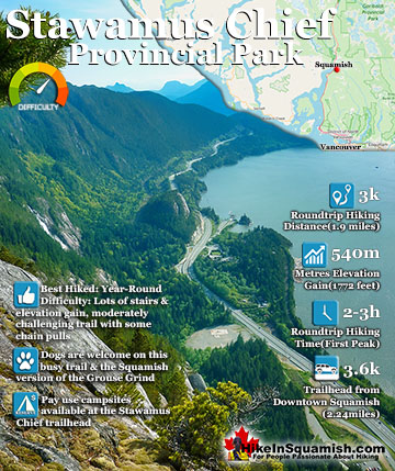
Stawamus Chief is the mammoth rock face that towers over Squamish. Though hardly believable from looking at, the summit is a fairly easy, though very steep hike. In fact there are three peaks, South (First), ...
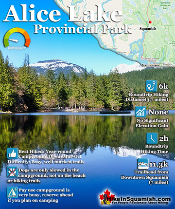
Alice Lake is a great place for camping swimming, fishing and hiking. Alice Lake Provincial Park is comprised of four lakes, Stump, Fawn and Edith Lake as well as the much larger Alice Lake. There is a nice trail, ...
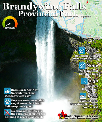
Brandywine Falls is one of the must see sights on the drive to or from Whistler, and arguably the nicest of Whistler’s numerous beautiful waterfalls. Located about halfway between Squamish and Whistler, the ...
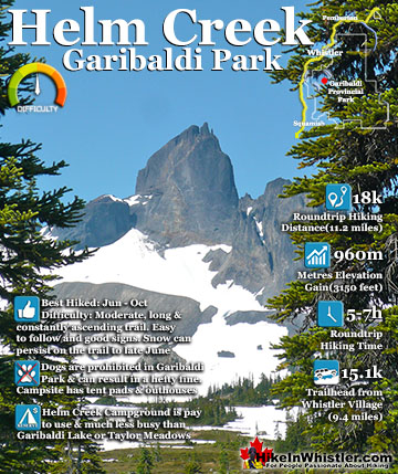
Helm Creek is a cute, meandering creek that winds its way from beyond Black Tusk, down the valley to the wonderful campground that takes its name. From the Helm Creek campground, Helm Creek descends further ...
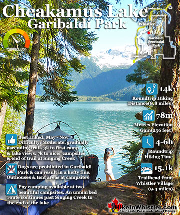
Cheakamus Lake is a wonderfully relaxing way to get in the wilderness easily and quickly from Whistler Village. The trail begins on the far side of Whistler Mountain, 8 kilometres from the Sea to Sky ...
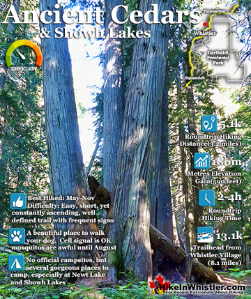
Ancient Cedars is a nice, easy/moderate 2.5 kilometre(1.6 mile) hiking trail on the far side of Cougar Mountain, just 10.8 kilometres(6.7 miles) north of Whistler Village. A small, untouched grove of huge ...
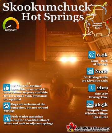
Skookumchuck Hot Springs (aka: T'sek Hot Springs and St Agnes Well Hot Springs) is located two hours north of Whistler along the edge of Lillooet River. The name Skookumchuck means "strong water" in the ...
Whistler is an amazing place to hike. Looking at a map of Whistler you see an extraordinary spider web of hiking trails. Easy trails, moderate trails and challenging hiking trails are all available. Another marvellous thing about Whistler is that Garibaldi Provincial ...
Squamish sits in the midst of some amazing places to hike. Garibaldi Park sprawls from Squamish up and beyond Whistler. Tantalus Provincial Park lays across the valley to the west and the beautiful and desolate, by comparison, Callaghan Valley to the north. Add to ...
Clayoquot Sound has a staggering array of hiking trails within it. Between Tofino and Ucluelet, Pacific Rim Park has several wilderness and beach trails, each one radically different from the last. The islands in the area are often Provincial parks on their own with ...
Victoria has a seemingly endless number of amazing hiking trails. Most take you to wild and beautiful Pacific Ocean views and others take you to tranquil lakes in beautiful BC Coastal Rainforest wilderness. Regional Parks and Provincial Parks are everywhere you turn ...
The West Coast Trail was created after decades of brutal and costly shipwrecks occurred along the West Coast of Vancouver Island. One shipwreck in particular was so horrific, tragic and unbelievable that it forced the creation of a trail along the coast, which ...