Squamish sits in the midst of some amazing places to hike. Garibaldi Provincial Park sprawls from Squamish up and beyond Whistler. Tantalus Provincial Park lays across the valley to the west and the beautiful and desolate, by comparison, Callaghan Valley to the north.
GaribaldiProvincialPark
Garibaldi Provincial Park wraps around Squamish and is home to some amazing hiking trails. Garibaldi Lake, Panorama Ridge, Black Tusk and Elfin Lakes are all wonderful hiking destinations in this extraordinary Provincial Park so close to Squamish.
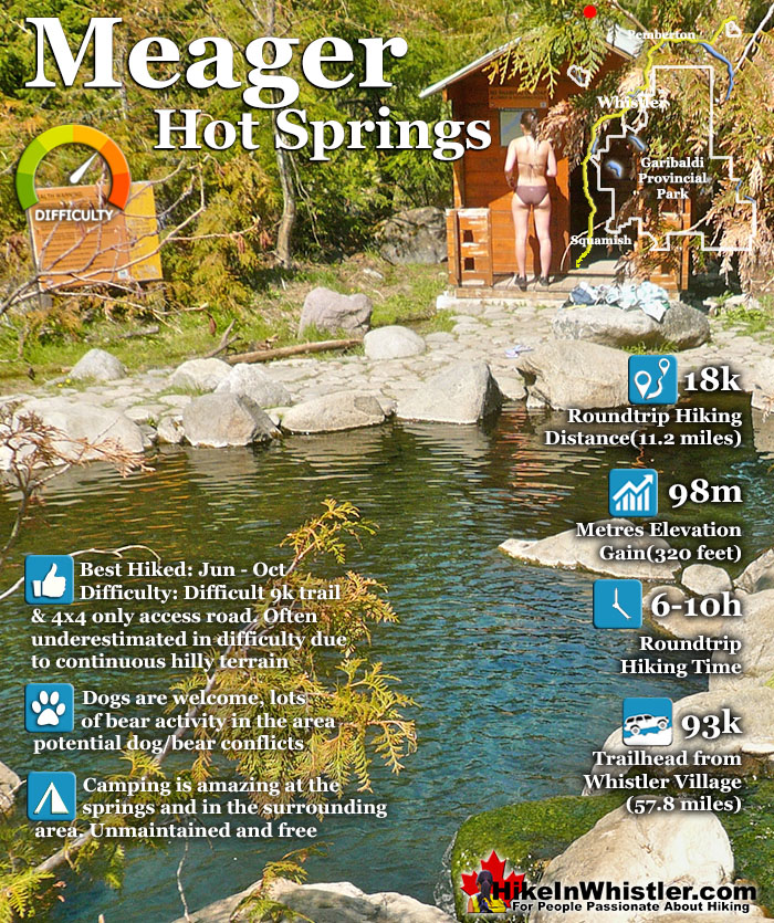
Meager Hot Springs(aka: Meager Creek Hot Springs) is located 93 kilometres northwest of Whistler, was beautifully developed into gorgeous pools, with a caretaker and usage charge. At its height of popularity, Meager Hot Springs had 30,000 yearly visitors. Unfortunately, due to two recent avalanches it seems unlikely to ever officially reopen. After several years of being closed, access reopened on 2009 with a nice, expensive, new bridge.
Only to be dramatically obliterated from another slide in 2010. In 2014 the new VOC Harrison Hut Trail was mostly completed, allowing access to Meager Hot Springs once again. Currently this access road is in a bit of a construction zone, so don't be surprised if the road is blocked by a rock slide or road construction. The old access bridge over the Upper Lillooet River which cost nearly a million dollars was wrecked in seconds in 2010. There was considerable wrangling and negotiating to get it built in in 2009, but now it will almost certainly never be rebuilt. The area is far too active. Access to the springs is now via the new Harrison Trail via the south side of the the Upper Lillooet River, above and beyond the still visible, still awe inspiring, mudslide carnage. With the catastrophic mud and debris slide let loose from Devastator Peak in 2010, the nice new (in 2009) million dollar bridge to the Meager Hot Springs was destroyed. Though destroyed doesn't even begin to describe it. Looking on the now, dead end road, where the bridge once stood, the place still looks a mess. "Meager Creek FSR is closed indefinitely; no access to the hot springs." This is from the BCParks Upper Lillooet Provincial Park site, and evidently quite accurate. Dead and still dying grey ghosts of trees still stand as they did in piles of forest wreckage. Even the road in looks bizarre. The road was simply bulldozed back to life. On either side, hemmed in by piles of dirt and dead trees. In the last couple years BC Ministry of Forests and Recreation Sites and Trails BC have been aggressively blocking public access to both Meager Hot Springs and Keyhole Hot Springs. Currently, in 2023 they have blocked both access roads with gates to the trailheads and are threatening to issue violation tickets. The warning reads: SITE CLOSED: Meager Hot Springs are within Lil̓wat Nation territory. This is a place of cultural and spiritual significance for Lil̓wat Nation. The site closure supports the protection of important cultural, environmental, and wildlife values. The Meager Creek Drainage is prone to extremely large landslides, avalanches, and flooding/washouts. The Province will be enforcing this closure and will issue violation tickets to anyone caught ignoring the restrictions. They don't appear to have any legitimate reasons for the closures and are clearly making up vague things to justify blocking public access. For example: "Mineral licks at the hot springs provide wildlife with year-round nutrients. The hot springs are also home to the vivid dancer damselfly, a species of special concern that is threatened by intensive recreational use. Meager Creek Hot Springs is the only known location within BC where the American bulrush (Schoenoplectus americanus) grows".
Meager Mudslide Carnage
The mudslide carnage after the slide was quite a sight to see. The striking contrast of lush, tree covered mountains and the valley floor a brown, lifeless carpet of powdery dirt and dead trees. You could see, with alarming clarity, the path the slide carved out as it barrelled through the valley. At its peak of popularity in 1994, Meager Hot Springs had 30,000 visitors a year. With the unrestrained numbers, vandalism and violence broke out at the springs often so the BC Forest Service stepped in. They hired an on-site supervisor, limited vehicle access and charged a usage fee. Then the big slide of 2010 happened and now of course it only gets a few, very motivated visitors.
Path of the Meager Mudslide in 2013
Bridge to Meager Hot Springs Before and After
Harrison Trail View of Mount Meager
Harrison Trail View of Meager Mudslide Path
Mount Meager
The Old Meager Creek Hot Springs Welcome Sign
Beautiful Meager Creek Hot Springs
Meager Hot Springs Map
The Harrison Hut and Meager Hot Springs trailhead shown here has been accessible by car in the past, however the access road has been found blocked occasionally in the past couple years. Keep that in mind as you may have to park and walk to the trailhead.
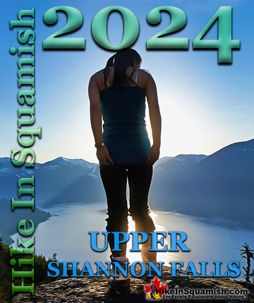
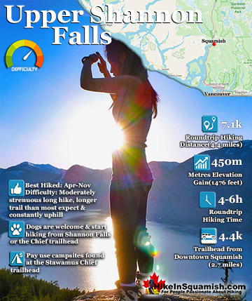
The wonderful Upper Shannon Falls trail, also called the Sea to Summit trail, branches off from the chaotically popular Stawamus Chief trail. About 15 minutes along the Stawamus Chief trail you will see a ...
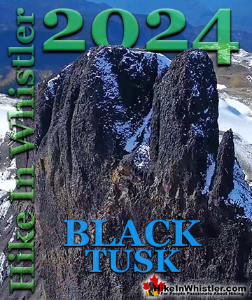
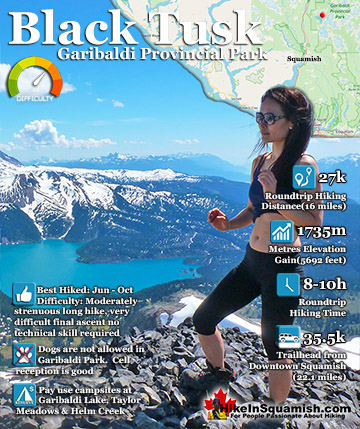
Black Tusk is the extraordinarily iconic and appropriately named mountain that can be seen from countless vantage points around Whistler. The massive black spire of crumbling rock juts out of the earth in an ...
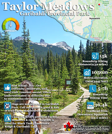
Taylor Meadows is a beautiful campsite and alternative to the much busier and more well known, Garibaldi Lake campsite. Located in between Garibaldi Lake and Black Tusk itself. It is reached from the same ...
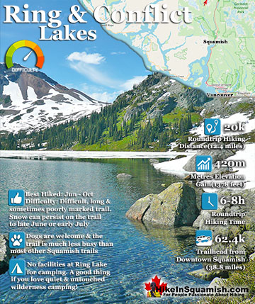
Ring Lake is a fantastically beautiful and wonderfully remote lake similar to Cirque Lake but considerably farther to hike to reach it. The 10 kilometre hike takes you through a tranquil forest, then to a ...
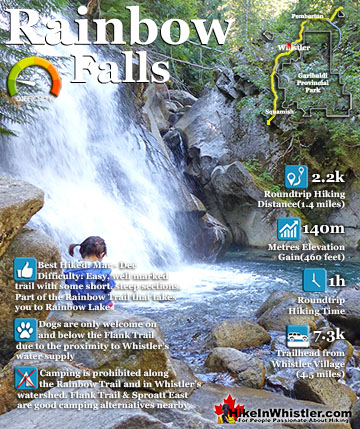
The short, scenic and easy hiking trail to Rainbow Falls is found at the same, much more well known trailhead for Rainbow Lake. The trailhead is marked as the Rainbow Trail and the trail quickly ascends ...
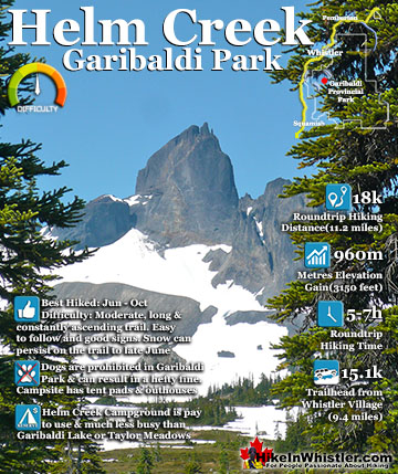
Helm Creek is a cute, meandering creek that winds its way from beyond Black Tusk, down the valley to the wonderful campground that takes its name. From the Helm Creek campground, Helm Creek descends further ...
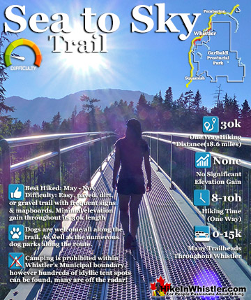
The Sea to Sky Trail is a 180 kilometre multi-use trail that runs from Squamish to D'Arcy. The trail is still under construction in many parts, however, the amazing route through Whistler is finally in ...
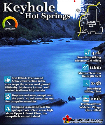
Keyhole Hot Springs(sometimes called Pebble Creek Hot Springs) is located 100 kilometres from Whistler(Village Gate Blvd). Though most of the 100 kilometres is on logging roads, it is driveable by most cars ...
Whistler is an amazing place to hike. Looking at a map of Whistler you see an extraordinary spider web of hiking trails. Easy trails, moderate trails and challenging hiking trails are all available. Another marvellous thing about Whistler is that Garibaldi Provincial ...
Squamish sits in the midst of some amazing places to hike. Garibaldi Park sprawls from Squamish up and beyond Whistler. Tantalus Provincial Park lays across the valley to the west and the beautiful and desolate, by comparison, Callaghan Valley to the north. Add to ...
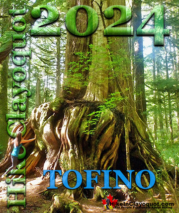
Clayoquot Sound has a staggering array of hiking trails within it. Between Tofino and Ucluelet, Pacific Rim Park has several wilderness and beach trails, each one radically different from the last. The islands in the area are often Provincial parks on their own with ...
Victoria has a seemingly endless number of amazing hiking trails. Most take you to wild and beautiful Pacific Ocean views and others take you to tranquil lakes in beautiful BC Coastal Rainforest wilderness. Regional Parks and Provincial Parks are everywhere you turn ...
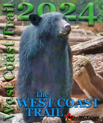
The West Coast Trail was created after decades of brutal and costly shipwrecks occurred along the West Coast of Vancouver Island. One shipwreck in particular was so horrific, tragic and unbelievable that it forced the creation of a trail along the coast, which ...


")