Squamish sits in the midst of some amazing places to hike. Garibaldi Provincial Park sprawls from Squamish up and beyond Whistler. Tantalus Provincial Park lays across the valley to the west and the beautiful and desolate, by comparison, Callaghan Valley to the north.
GaribaldiProvincialPark
Garibaldi Provincial Park wraps around Squamish and is home to some amazing hiking trails. Garibaldi Lake, Panorama Ridge, Black Tusk and Elfin Lakes are all wonderful hiking destinations in this extraordinary Provincial Park so close to Squamish.
Aerial views of Squamish, Whistler and Garibaldi Provincial Park. Beautiful Cirque Lake high up in the Callaghan Valley way above Callaghan Lake. The Sea to Sky Gondola aerial views of Squamish and the Chief. Whistler Mountain, Blackcomb Mountain, Panorama Ridge and Wedgemount Lake in Garibaldi Provincial Park. Stunning and surreal aerial views of Joffre Lakes Provincial Park and more...
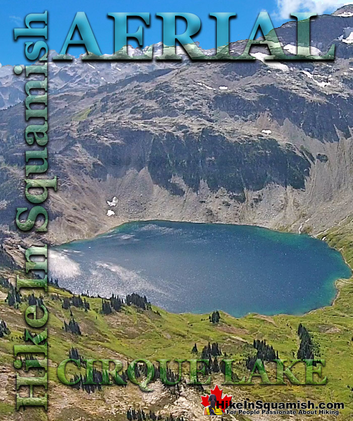
Cirque Lake is a wild and beautiful lake that hides high above and beyond Callaghan Lake in Callaghan Lake Provincial Park. What makes Cirque Lake special among the other sensationally beautiful lakes in the Whistler area is both its location and geologically formed shape. It sits high above Callaghan Lake, which itself is a gorgeous, mountain lake. The remoteness of Callaghan Lake is a bit of a mirage due to the fact that you can drive right to it! Callaghan Lake is accessible via an 8 kilometre weather battered and very potholed forest service road. The entire road is cratered with deep potholes, cut by frequent cross-ditches, and more recently a small section collapsing into the valley below. This logging road begins high up in the Callaghan Valley, which itself is largely overlooked by travellers to Whistler. The Callaghan Valley is home to quite a few natural and man-made attractions. Brandywine Meadows, Alexander Falls, Northair Mine and Mount Sproatt are all found in the valley.
Cirque Lake Aerial Views
One feature of the Cirque Lake trail that no doubt scares hikers away is its steepness and ruggedness. It is mostly very steep, and due to the obliterating effects of winter snow, the trail markers are sporadic at best. One consolation is of course the length of the trail. Under two kilometres, makes the steepness much easier to tackle. With a heavy pack you can easily hike the trail in a little over an hour. Or an hour and a half or two if you linger at the frequent viewpoints looking back on Callaghan Lake. The eruption of blueberry bushes in August is cause for some delays as well as it is surprisingly hard to pass up feasting on every bush you see.. and you will see a lot. The trail, for the most part is quite scenic and enjoyable. The first 15 minutes of the trail winds through a cute forest along and over some small streams. The next 15 minutes takes you up some steeper and more challenging terrain that require pulling yourself up with tree roots and at one section a knotted rope. Thirty minutes into the trail brings you to a massive boulder field that you have to budget your attention between the treacherous boulders ahead and the incredible views of Callaghan Lake behind. The final 15 minutes of the trail is the most enjoyable of all. Summiting the ridge that takes you to the access point entrance to Cirque Lake. This ridge has a clearing with breathtaking views overlooking Callaghan Lake. So beautiful that you will be tempted to drop your pack and spend the night. The real marvel of course lays just 5 minutes ahead.
Porteau Cove Provincial Marine Park
Porteau Cove is a beautiful little stop between Vancouver and Squamish. Located 19 kilometres south of Squamish, it is an ideal, scenic and quick pit-stop along the Sea to Sky Highway. There are public washrooms located just a off the highway. The marine park is centred around a wonderful pier with viewing platforms that jut out and above the ocean of this majestic and enormous Canadian fjord - the most southerly fjord in North America. Porteau Cove is well known in the Scuba Diving community for amazing diving. In fact a ship was purposely sunk in the area to increase the already amazing diving appeal. Other underwater curiosities make this a well used and beautiful place to dive. On any given day, you will see groups of scuba divers in the distance or getting in or out of the water. The scuba diver entry area by the boat ramp has a nice description of what is under the water that makes it such a fascinating place to dive. One the pier you will find an interpretive tour of sorts as their are descriptions, every few metres along the railings of what you may see from the pier viewpoints.
Sea to Sky Gondola Aerial Views
Located between Stawamus Chief Provincial Park and Shannon Falls Provincial Park the gondola carries you rapidly from the sea to the sky. Departing just a few hundred metres from the ocean at an elevation of 35 metres, to 885 metres in just minutes. In early June you will still feel the chill in the air from the snowy mountain peaks all around. At the top of the gondola you arrive at the spectacular Summit Lodge. You immediately are drawn to enter this cliff-edge building with a restaurant, coffee shop, bar and an enormous sundeck that stretches around half of the building. The sundeck has dozens of tables and of course views of everything. Gondola's coming and going, Howe Sound, Sky Pilot and Co-Pilot(mountains). At one end of the sundeck the Sky Pilot Suspension Bridge extends across a chasm to a rocky outcrop in the direction of Sky Pilot Mountain.
Stanley Park Aerial Views
Stanley Park in downtown Vancouver is a beautiful and astoundingly huge network of hiking/walking/biking trails. An estimated 8 million hikers, walkers, rollerbladers and cyclists visit the park yearly. The wonderful spider web of trails throughout the park add up to a staggering 200 kilometres, which explains how the park generally feels serene and relatively quiet most days despite its phenomenal popularity. Stanley Park can be walked or biked in any number of routes and lengths. Certainly one of the popular, and most straight forward routes is by a large, 10k circle, paved trail that runs around the perimeter. Stanley Park can be walked or biked in any number of routes and lengths. Certainly one of the popular, and most straight forward routes is by a large, 10k circle, paved trail that runs around the perimeter. You can park at one end, for example near English Bay, and head along the coastal, paved trail and follow the beautiful circumference of Stanley Park and return to where you started after a wonderful and constantly scenic 10 kilometre seawall route.
Callaghan Lake Provincial Park Aerial Views
Callaghan Lake Provincial Park is a relatively untouched wilderness of rugged mountainous terrain. The valley walls were formed by relatively recent glaciation. Evidence of this can be seen in the considerable glacial till and slide materials visible across the lake. Around the lake you will see talus slopes, flat rock benches, cirques, hanging valleys, tarns, waterfalls and upland plateaus with bogs. The wildlife that reside in the area include bobcats, cougars, coyotes, minks, wolverines, wolves, bears, deer, mountain goats and occasionally moose and grizzly bears. Callaghan Lake is not really a hiking destination but more of a drive to campsite on a beautiful lake, and gateway to some beautiful intermediate hikes. The campsite is small and looks a bit like a parking lot with about a dozen spots to put up a tent near your vehicle.
Whistler Mountain Aerial Views
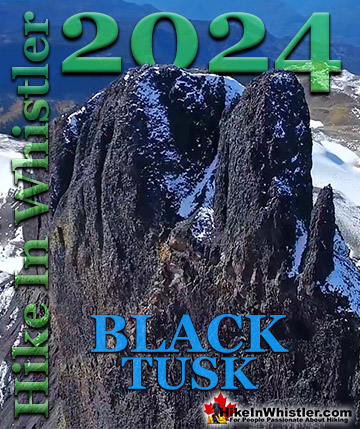
The alpine hiking trails on Whistler Mountain are the ultimate in luxurious hiking. Little hiking effort gets you amazing views of turquoise lakes, snowy mountain, valleys of flowers, waterfalls and spectacular glaciers. In the summer months, Whistler Mountain is somewhat divided in two. The lower half of the mountain is for biking and the upper half is for hiking, sightseeing, trail running, eating and drinking. There are a few directions you can start hiking from the Roundhouse Lodge, however, taking the Peak Express(quad chairlift) up to the summit of Whistler Mountain is an amazing place to start. The Peak Express is an exhilarating ride that takes you to the start of Whistler Mountain's best hiking trails. The Half Note Trail, High Note Trail and Mathew's Traverse start here. The High Note Trail in turn leads to the Musical Bumps Trail to Russet Lake and Singing Pass in Garibaldi Provincial Park. The summit of Whistler Mountain is also a destination of its own. Spectacular views all around from this rocky, alpine summit visible from almost everywhere in Whistler. Black Tusk comes into view as you exit the Peak Express. This amazingly distinct pinnacle of jet-black rock is a local icon and remnant of a not too distant history of volcanism in the area. As you admire its absurdly vertical form, remind yourself that there is almost certainly a few hikers looking back at you from its summit.
Wedgemount Lake Aerial Views
Wedgemount Lake itself is a magnificent destination for a day hike or spectacular overnight beneath the dazzling mountain peaks and stars. Many sleep under the stars on one of the many beautiful tent platforms that dot the landscape. Solidly built, wooden tent platforms are everywhere you look at Wedgemount Lake. Strategically positioned, these platforms manage to maintain an amazingly secluded feel despite their numbers. In all Wedgemount Lake has 20 of these tent areas. Most are wooden, but several down by the lake shore are gravel, yet every bit as nice. Due to a big snow winter, the Wedgemount Lake trail was very difficult to hike due to snow well into June 2017! Wedgemount Lake is one of the most spectacular hikes in Garibaldi Park. Though it is a relentlessly exhausting, steep hike, it is mercifully short at only 7 kilometres one way. The elevation gain in that short distance is over 1200 metres which makes it a much steeper hike than all the other Whistler area hiking trails. Compared with other Whistler hikes, Wedgemount Lake is half the roundtrip distance of either Black Tusk or Panorama Ridge, for example, at 13.5 kilometres and 15 kilometres respectively (one way).
Panorama Ridge Aerial Views
Panorama Ridge is easily one of the most amazing hikes in Garibaldi Provincial Park. The 15 kilometre hike from the trailhead at Rubble Creek to Panorama Ridge takes you through beautiful and deep forests, across countless idyllic streams, through meadows filled with flowers, and past dozens of jaw dropping viewpoints. The amazing views start once you reach Taylor Meadows and get even more spectacular as the trail progresses. Once you arrive at Panorama Ridge and its phenomenal vantage point, high above Garibaldi Park, you will stare in wonder. Mesmerized first by Garibaldi Lake, far below you and looking unnaturally blue, the lake looks amazing surrounded by green, untouched wilderness and snow capped mountains. The Table, the massive and unusual looking mountain with its bizarre flat top lays across the lake with the enormous Mount Garibaldi just beyond. In the distance, where Garibaldi Lake ends, a massive glacier rises out of the blue and jagged crevasses can be seen even from such a great distance.
Explore Whistler Hiking Trails!
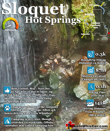
Sloquet Hot Springs is a wonderfully wild set of shallow, man-made pools fed by a small, all natural, and very hot, waterfall. The pools stretch from the waterfall to the large and crashing Sloquet River. ...
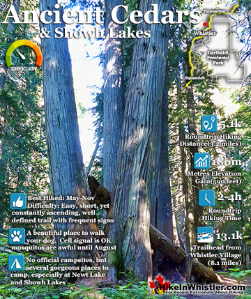
Ancient Cedars is a nice, easy/moderate 2.5 kilometre(1.6 mile) hiking trail on the far side of Cougar Mountain, just 10.8 kilometres(6.7 miles) north of Whistler Village. A small, untouched grove of huge ...
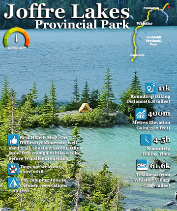
The three Joffre Lakes are some of the most stunning lakes you are likely to ever see. Each lake gets progressively more beautiful and impossibly turquoise from one to the next. By the third lake the intense ...
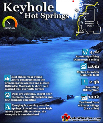
Keyhole Hot Springs(sometimes called Pebble Creek Hot Springs) is located 100 kilometres from Whistler(Village Gate Blvd). Though most of the 100 kilometres is on logging roads, it is driveable by most cars ...
Whistler is an amazing place to hike. Looking at a map of Whistler you see an extraordinary spider web of hiking trails. Easy trails, moderate trails and challenging hiking trails are all available. Another marvellous thing about Whistler is that Garibaldi Provincial ...
Squamish sits in the midst of some amazing places to hike. Garibaldi Park sprawls from Squamish up and beyond Whistler. Tantalus Provincial Park lays across the valley to the west and the beautiful and desolate, by comparison, Callaghan Valley to the north. Add to ...
Clayoquot Sound has a staggering array of hiking trails within it. Between Tofino and Ucluelet, Pacific Rim Park has several wilderness and beach trails, each one radically different from the last. The islands in the area are often Provincial parks on their own with ...
Victoria has a seemingly endless number of amazing hiking trails. Most take you to wild and beautiful Pacific Ocean views and others take you to tranquil lakes in beautiful BC Coastal Rainforest wilderness. Regional Parks and Provincial Parks are everywhere you turn ...
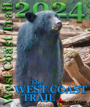
The West Coast Trail was created after decades of brutal and costly shipwrecks occurred along the West Coast of Vancouver Island. One shipwreck in particular was so horrific, tragic and unbelievable that it forced the creation of a trail along the coast, which ...


")