Squamish sits in the midst of some amazing places to hike. Garibaldi Provincial Park sprawls from Squamish up and beyond Whistler. Tantalus Provincial Park lays across the valley to the west and the beautiful and desolate, by comparison, Callaghan Valley to the north.
GaribaldiProvincialPark
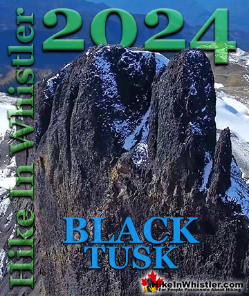
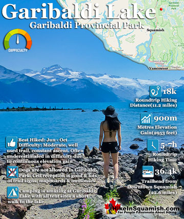
Garibaldi Provincial Park wraps around Squamish and is home to some amazing hiking trails. Garibaldi Lake, Panorama Ridge, Black Tusk and Elfin Lakes are all wonderful hiking destinations in this extraordinary Provincial Park so close to Squamish.
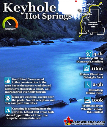
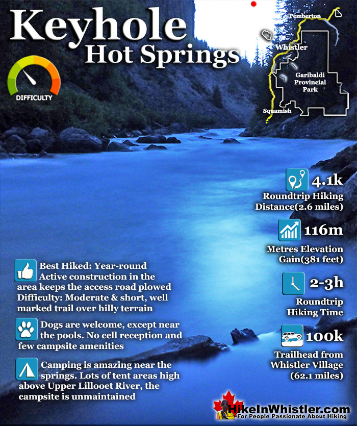
Keyhole Hot Springs(sometimes called Pebble Creek Hot Springs) is located 100 kilometres from Whistler(Village Gate Blvd). Though most of the 100 kilometres is on logging roads, it is driveable by most cars without any trouble. The massive Innergex hydroelectric project has turned this once quiet wilderness into a war-zone. On the plus side, the old logging roads near Keyhole Hot Springs are now well maintained and smooth.
2014 saw the permanent closing of the old hot springs trail and a new trail built. Another benefit of the construction is the year-round maintenance of the access road which allows access to the springs even in the winter. The spectacular Keyhole Falls is located just a couple kilometres upriver from the hot springs and very close to ground zero of the Innergex mammoth construction effort. If you are brave enough to drive to the Keyhole Falls trail, just continue driving past the Lillooet River trail. You will see a large, unmarked parking area and hard to find trail just before the km 50. If you have doubts that you are parking in the right spot, just get out of your vehicle and listen for a moment. The deep rumbling of Keyhole Falls can be faintly heard from where you park. Climb the gravel embankment(don't cross the vehicle bridge) and look for the faint trail, then follow the faint rumbling from the falls as it soon becomes a thundering echo far below. The trail is just a couple hundred metres long from the parking area. The reason you have to be brave to get to Keyhole Falls is because of the colossal war zone you have to drive through to get to it. It is a bit daunting, however, access to the area is still allowed. You just have to be very aware of being considerate to the massive construction vehicles scrambling to get the job done. There are large signs indicated where you cannot go, which makes navigating to the falls more manageable. Back at the Lillooet River trail, you will find a trailhead parking area, a small sign and permanent outhouse. A new sign now marks the start of the route to Keyhole Hot Springs. In the last couple years BC Ministry of Forests and Recreation Sites and Trails BC have been aggressively blocking public access to both Meager Hot Springs and Keyhole Hot Springs. Currently, in 2023 they have blocked both access roads with gates to the trailheads and are threatening to issue violation tickets. The warning reads: SITE CLOSED: Trail and hot springs are closed from Apr 1 to Nov 15 each year (spring to fall) The Province will be enforcing this closure and will issue violation tickets to anyone caught ignoring the restrictions. They don't appear to have any legitimate reasons for the closures and are clearly making up vague things to justify blocking public access. For example: "The Upper Lillooet provides important habitat for many wildlife species, including the threatened South Chilcotin grizzly bear population, and is a very important wildlife migration corridor for deer, moose, and mountain goats. Mineral licks at the hot springs provide wildlife with year-round nutrients. The hot springs are also home to the vivid dancer damselfly, a species of special concern that is threatened by intensive recreational use. Ad hoc water diversion mechanisms and user created tubs disturb natural features and alter stream flow, negatively impacting the ecosystem. Human activity at the hot springs can displace wildlife from these valuable habitat features."
This new trail is 2 kilometres long and moderately challenging as it skirts the rugged terrain along the Upper Lillooet River. A couple of sections are very steep, and it is easy to stray from the trail. Along the trail there are at least two fantastic and inviting areas along the trail (beside the river) perfect for camping. Closer to Keyhole Hot Springs, the very nice camping area high up, overlooking the river is still as it has always been. Nice, rustic, wild and of course, unmaintained. The new Lillooet River trail is well marked with flagging tape and tree reflectors as well as the occasional bench to sit on. Just like the old trail, this new trail is often challenging to navigate. Though it is rarely steep, as the old trail mostly is, this one is a zig-zag through a thick forest and occasional scramble through truck sized boulders. The trail, at a moderate pace should take about a half an hour from your car to the springs. If you have any interest in geology, however, the trail may take you hours. The crumbing cliffs reveal an astounding array of recent volcanic activity and you find yourself staring in amazement at the extraordinarily beautiful rocks.
Garibaldi Lake is the centre and base for much of the hiking in Garibaldi Provincial Park. The Garibaldi Lake campsite is located on the amazing, turquoise shores of this massive and mostly still wild ...
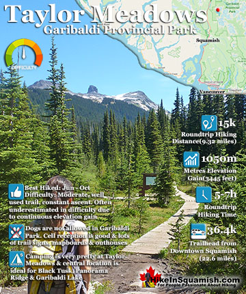
Taylor Meadows is a beautiful campsite and alternative to the much busier and more well known, Garibaldi Lake campsite. Located in between Garibaldi Lake and Black Tusk itself. It is reached from the same ...
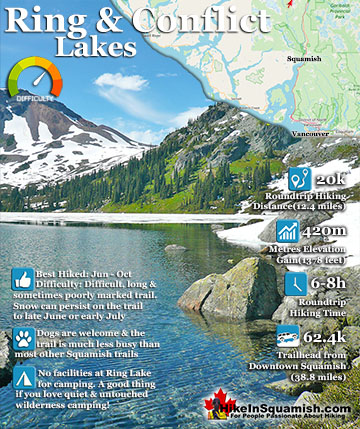
Ring Lake is a fantastically beautiful and wonderfully remote lake similar to Cirque Lake but considerably farther to hike to reach it. The 10 kilometre hike takes you through a tranquil forest, then to a ...
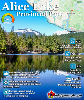
Alice Lake is a great place for camping swimming, fishing and hiking. Alice Lake Provincial Park is comprised of four lakes, Stump, Fawn and Edith Lake as well as the much larger Alice Lake. There is a nice trail, ...
Keyhole Hot Springs(sometimes called Pebble Creek Hot Springs) is located 100 kilometres from Whistler(Village Gate Blvd). Though most of the 100 kilometres is on logging roads, it is driveable by most cars ...
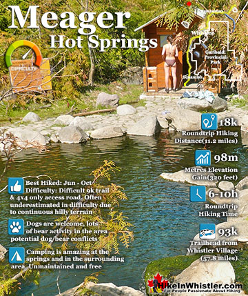
Meager Hot Springs(aka: Meager Creek Hot Springs) is located 93 kilometres northwest of Whistler, was beautifully developed into gorgeous pools, with a caretaker and usage charge. At its height of ...
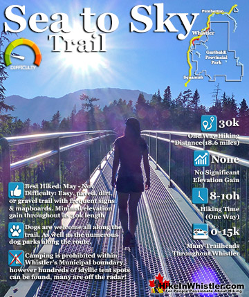
The Sea to Sky Trail is a 180 kilometre multi-use trail that runs from Squamish to D'Arcy. The trail is still under construction in many parts, however, the amazing route through Whistler is finally in ...
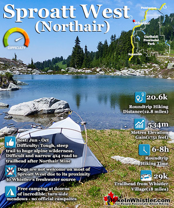
Mount Sproatt, or as it is known locally as just Sproatt, is one of the many towering mountains visible from Whistler Village. Above and beyond Alta Lake, directly across from Whistler Mountain and Blackcomb ...
Whistler is an amazing place to hike. Looking at a map of Whistler you see an extraordinary spider web of hiking trails. Easy trails, moderate trails and challenging hiking trails are all available. Another marvellous thing about Whistler is that Garibaldi Provincial ...
Squamish sits in the midst of some amazing places to hike. Garibaldi Park sprawls from Squamish up and beyond Whistler. Tantalus Provincial Park lays across the valley to the west and the beautiful and desolate, by comparison, Callaghan Valley to the north. Add to ...
Clayoquot Sound has a staggering array of hiking trails within it. Between Tofino and Ucluelet, Pacific Rim Park has several wilderness and beach trails, each one radically different from the last. The islands in the area are often Provincial parks on their own with ...
Victoria has a seemingly endless number of amazing hiking trails. Most take you to wild and beautiful Pacific Ocean views and others take you to tranquil lakes in beautiful BC Coastal Rainforest wilderness. Regional Parks and Provincial Parks are everywhere you turn ...
The West Coast Trail was created after decades of brutal and costly shipwrecks occurred along the West Coast of Vancouver Island. One shipwreck in particular was so horrific, tragic and unbelievable that it forced the creation of a trail along the coast, which ...


")